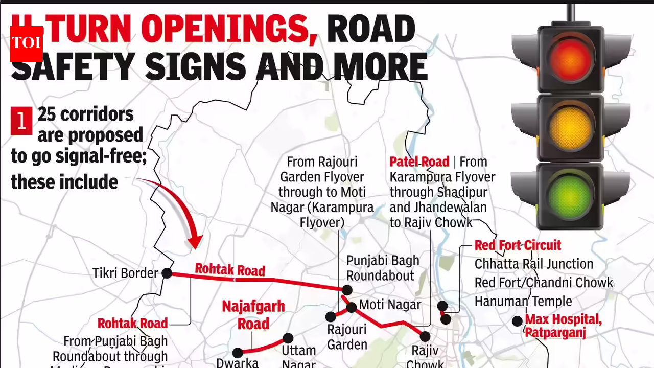
New Delhi: At a time when work is underway to make at least seven major corridors of Delhi free of signals, authorities have turned their attention to another 25 stretches across the city. From Dwarka Mor to Mehrauli-Gurgaon Road, these corridors will be studied to assess whether the model can work there, too.This follows a proposal submitted in mid-June by Atul Ranjit, national general secretary of Guru Hanuman Society of India, an NGO. In his letter, Ranjit pitched a U-turn-based traffic management system to ease congestion. According to the proposal, the system could help reduce pollution; save commuters’ time, fuel, money and energy; protect trees from dust and chemical deposits; and minimise other adverse impacts of traffic on the environment.Special CP (traffic) Manish Kumar Agarwal said, “Delhi Traffic Police is committed to improve mobility through practical engineering interventions within the existing road infrastructure. Developing signal-free corridors, wherever feasible, is a key part of this strategy. In partnership with the NGO, we are identifying stretches that can be converted into signal-free routes, thus helping reduce congestion, improve travel time and enhance road user experience.”This comes even as work is underway to make several stretches signal-free. They include Rajghat and west Delhi’s Najafgarh Road, covering the stretch from Rajouri Garden Flyover to Vishal Cinema.Encouraged by the progress of the ongoing projects, the NGO has proposed extending the model to 25 more corridors. They include about a dozen intersections in Dwarka; Najafgarh Road – from Uttam Nagar to Dwarka Mor and from Rajouri Garden Flyover to Moti Nagar; Rohtak Road – from Punjabi Bagh to the Tikri-Bahadurgarh border; Red Fort Circuit covering Chhatta Rail Junction, Red Fort, Chandni Chowk, Daryaganj, Delhi Gate, Rajghat, Shanti Van and Hanuman Temple; and Patel Road – from Karampura Flyover to Rajiv Chowk.The proposal also covers Maharaja Nahar Singh Marg – from Inderlok Metro Station to Prembari Vehicle Underpass; Mehrauli-Gurgaon Road; Captain Gaur Marg; Mathura Road – from Ashram to Badarpur border; Badli-Bawana Road; Outer Ring Road covering Okhla, Nehru Place, Chirag Delhi Flyover, IIT Flyover, Hauz Khas, Munirka, RK Puram and Rao Tula Ram Flyover; Ring Road – from Mall Road to Civil Lines; and UER-I – from NH-44 to Narela and Bawana.Other locations in focus include Kalindi Kunj; the Ring Road stretch beneath Jhulelal Flyover; airport and Palam areas; Pankha Road; Mehrauli-Badarpur Road; all traffic signals beneath UER-II; Max Hospital Patparganj area; Model Town traffic signals on Ring Road; the IIT area; and, as a policy, all roads with at least three lanes in each direction.Sanjay Tyagi, joint CP (traffic), said, “Our aim is to improve traffic flow by reducing unnecessary stoppages at signals while ensuring safety. We have enhanced traffic management through better deployment of personnel and continuous monitoring, with work on several signal-free corridors in progress. Another 25 stretches will now undergo feasibility studies; the model will be implemented wherever it is found suitable.“However, some Delhiites are concerned about the impact the move could have on pedestrians. Amit Aggarwal, a resident of Vasant Kunj, said, “This is a major mistake. Instead of removing traffic signals, they should be synchronised to improve traffic flow while ensuring safe pedestrian crossings. On major roads, foot overbridges are not a convenient alternative for many people. Making more stretches signal-free could further restrict pedestrian movement and increase the risk of accidents.“